News that the government is engaging the services of Dr Lui Thai-Ker from Sinagapore, ”an acclaimed master planner and architect of modern Singapore” to plan Accra and its surrounding towns has been greeted with mixed reactions.
So far, none of the reactions I have read or heard has questioned the competence and pedigree of Dr Thai-Ker. He is indeed one of the principals of the modern Singapore skyline and in particular, the public housing sector.
He rose to become the CEO of the Housing Development Board (HDB), the body with principal responsibility for planning and development of housing.
He also became CEO of the Urban Redevelopment Authority of Singapore – the body with responsibility for urban renewal and redevelopment.
In these positions, he has seen and done it all. What we don’t know is his experience in urban planning and development in Africa and the capacity he currently has under his command in his new role as a private sector person.
The comments also point to the need for transparent procurement and the inclusion of local professionals in the exercise.
I have also heard two contrary views as to whether the focus on planning Accra is the right one.
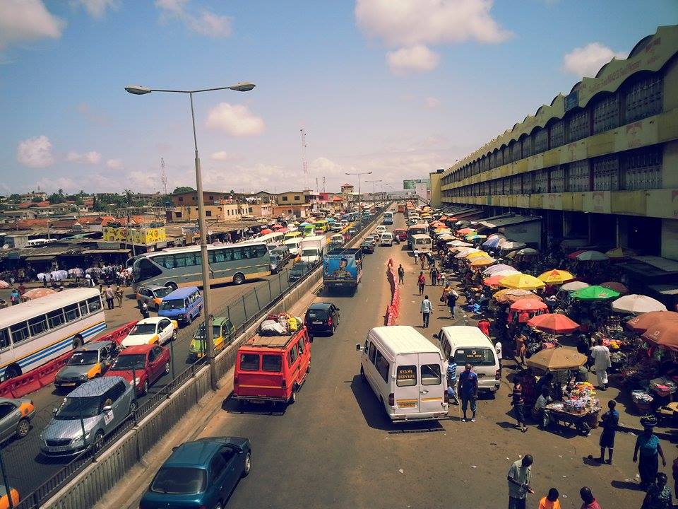
According to one view, given the traffic gridlock, the filth everywhere, the messy network of leaking water pipes and electrical wires, the sprawl of informal settlements, the lack of greenness and public spaces, the absence of a unique cultural character of the city, the severe shortage of affordable housing, Accra must be remodelled if it is to be workable.
The alternative argument is that this is completely the wrong focus. Accra is already too messed up to be realistically and affordably remodelled.
Accra’s land ownership is not like Singapore where the government owns most of it and can easily reorganise leases.The best you can do with Accra is to tweak it around the edges, expand roads, sort out public transport, including light rail, drainage and water management, encourage vertical construction and apartments rather than individual villas and enforce planning laws. Anything else is ‘fool’s paradise.’
Migration dilemma
The second reason for not focusing on Accra is migration. Dr Thai-Ker recognised this when he suggested that the planning of Accra should include “surrounding towns” in order not to exacerbate migration to Accra.
The second reason for not focusing on Accra is migration. Dr Thai-Ker recognised this when he suggested that the planning of Accra should include “surrounding towns” in order not to exacerbate migration to Accra.
But even the planning of “surrounding towns” will not do the trick. Migration to Accra is from far and wide. The proper approach, it is argued, is to focus on developing the smaller towns in all regions to encourage balanced urbanisation.This is also cheaper – these areas are less built-up, land values are lower compared to Accra or Kumasi and there is generally less expensive mess to correct.
Fortunately, there are already building blocks in place for the decentralised approach.
The SADA experience
The Land-Use and Spatial Planning Authority (LUSPA) has already done some good work developing a series of spatial plans, including the National Spatial Development framework, the Ashanti Regional Spatial Development framework and the Northern Savannah Spatial Development framework.
The Land-Use and Spatial Planning Authority (LUSPA) has already done some good work developing a series of spatial plans, including the National Spatial Development framework, the Ashanti Regional Spatial Development framework and the Northern Savannah Spatial Development framework.
These frameworks have good proposals on urban development and baseline data to build on. Also, urban planning is a long- term affair and the draft National Development Plan including the infrastructure plan provides a good basis to integrate specific urban plans.
I know the quality of LUSPA’s work because SADA partnered them (when they were still Town and Country Planning Department) to produce the Northern Savannah Spatial Development Framework (NSDF). It was the basis for the Northern Savannah Ecological Zone Development Concept Plan, that Singapore’s national planning agency, Surbana Jurong, helped to produce.
Surbana was the urban planning component of the Housing Development Board (HDB) which Dr Thai-Ker was CEO of, and the Jurong part deals with industrial planning.
Given the renewed interest in urban planning, which I take the Senior Minister’s initiative to imply, perhaps we can share the SADA (now NDA) experience in the planning of Tamale and Buipe. What does it take? What were the outputs? What will it take to implement?
To be clear, I am not a spatial planner but a development economist with a little bit of training in geography.
Development economists are concerned with how the macro and the micro interact through mediating institutions to address such matters as sectoral output, competitiveness and welfare and in that sense, space comes in somewhat.
What we need
The little I know of spatial planning is a three-year hands- on experience at SADA/NDA which taught me useful lessons.
The little I know of spatial planning is a three-year hands- on experience at SADA/NDA which taught me useful lessons.
1. Urban (and any spatial planning) is a multi-sectoral endeavour and by nature focuses on the long-term, working backwards to the short and medium. You need demographers and economists to project the population and economic growth dynamics; engineers (transport, energy, water, sanitation) and surveyors to lay out these structures in an integrated manner and guided by demographic projections, experts in satellite imagery, G IS and telecommunications infrastructure and architects to give ICT, land economists, health and education planners, spatial planners to generate the land- use plans and the architects, environmental scientists and forestry experts to give character to the built environment.
2. It takes a lot of stakeholder consultations and strong inter-ministerial coordination to work. For the Tamale and Buipe plans, SADA put together three local expert and oversight groups to work with Surbana Jurong: a National Steering Committee (made up of NDPC, LUSPA, the Ghana Institutions of Planners, Surveyor and, Architects as well as the Lands Commissions and other opinion leaders); a technical committee drawn from these professional groups and convened several forums to support the foreign team. A local oversight team in Tamale chaired by the Chief of Sagnarigu and involving the Assemblies (Tamale Metro, Sagnarigu Municipal and Buipe District Assembly) and the technical ministries and agencies drawn from the regional coordination councils to provide ground truth.
3. It takes time, money and effort to organise the extensive information needed for planning, including satellite and drone imagery,water pipeline networks, electricity grid; drainage systems, rainfall and climate, population, transport networks and regulations, health and education, existing bylaws and others. Anyone trying to obtain information from the public sector will understand the scale of the task.
No one is in a hurry to even sell it to you and when they do, they are in forms that need to be reorganised and verified. Unlike Singapore, where every tree along the boulevard is tagged and geo-positioned, Ghana has no respect for how information is organised.
4. An inspiring vision – derived from stakeholder consultations – is necessary to guide the planning effort.
The Greater Tamale Masterplan is guided by the vision of the city as a (i) Vibrant economy (ii) Cohesive and smart (iii) Nature conservation and recreation (iv)character and identity (v) Mobility and proximity (vi) Sustainable resource management.
That of Buipe is guided by a vision as (a) a thriving port city (b) inclusive city (c) waterfront city (d) a connected city (e) green city. These define how the space is organised.
5. A city should not be planned in isolation. What happens in that city depends on what happens hundreds of miles around it and its impact on surroundings. Tamale and Buipe were planned as a component of the wider northern savannah and deliberately connected to other cities, including Yendi, Damongo, Wa, Bolgatanga, Walewale, Bawku and Buipe, Kintampo and Dembai. Population movements and markets interact and for balanced development, these interactions must be deliberately studied and triggered. It is not sufficient to only understand what the planning of Accra will do to Dodowa or Nsawam or even Koforidua.
6. It is not sufficient to plan.The plan must be costed,an implementation framework developed alongside it and a financing model identified.The land issue must also be addressed frontally.Also,a capacity building strategy, involving planners must also be integrated into the arrangement with the foreign partner.
The Tamale and Buipe Masterplans are completed, endorsed by the respective mayors and Minister of Local Government and Rural Development (www.ndagh.org) and ready to be launched.
The plan outputs include (1) the data sets including satellite and drone imagery used to generate them (2) Structural Plans for Tamale and Buipe (3) The Online versions of the Masterplans (similar to the Kigali one) (4) Implementation frameworks (5) Detailed urban design complete with display models (6) A property tax management system, including attribute information and imagery for nearly 80,000 properties (7) A land management system by the current government, ready for launch. Tamale and Buipe have paved the way for other smaller towns and cities to follow.
BY: Charles Abugre
The Author is a Development Economist,
former CEO, SADA,
former Commissioner, NDPC and
co-convener of TAMA Foundation Universal


